Eating and Drinking
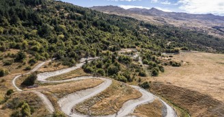
Shotover Gorge Trail
Arthurs Point - Frankton
Frankton Track Detour 2026 - Due to major infrastructure upgrades along the Frankton Track, a detour via the sealed footpath alongside Frankton Road will be in place throughout 2026. | Pest Control taking place at night (in darkness) adjacent to Countryside Trail at Slope Hill Reserve - Detour will be active between 28 March - 11 April. Please follow signage.

 Click and hold the Image to zoom
5.5 km one way from Arthurs Point to Tucker Beach
10.5 km one way from Arthurs Point to Old Lower Shotover Bridge (incl. Tucker Beach Trail)
Grade 3, with short sections of Grade 4 on the Hugo Tunnel section
To begin this epic adventure from the end of the Wharehuanui Trail outside Gantley's Tavern, take the Arthurs Point Link Trail towards Queenstown. You will follow the footpath, and then a short, steep descent to Atley Terrace, where you will see the trailhead for the Shotover Gorge Trail on the left. A gentle descent through Sycamore forest meanders above the Kimi-ākau Shotover river above Big Beach towards the lower gorge.
As the trail reaches the bluffs and seemingly a dead-end, the 108m long Hugo Tunnel provides a passage directly into the gorge, and combines a snapshot of the incredible mining history of the area with a spectacular trail experience. Stop here to read about the history of the tunnel, or pass through with the benefit of solar lighting, activated with a push button just inside the tunnel portal. The tunnel tramlines are left in-situ, so be wary and please walk your bike.
Once at the far end, Shotover Jetboats can be seen at close-quarters in the narrow canyon (no swimming!), and the trail turns back upstream to climb up to the lip of the gorge on ‘Lyttles Ladder’ – This section is narrow and steep, with a couple of grade 4 corners – less experienced cyclists should enjoy this short section as a walk and push their bikes up the switchbacks. Incredible views of the gorge below open up as you climb, and are best enjoyed from ‘Bucks Balcony’ as the trail weaves through ferns and native plantings towards Tucker Beach.
At the top of the tunnel climb, another rest area provides welcome relief at the junction with the tunnel bypass route. This intersection allows a connection with the Wharehuanui Trail via Littles Road and the Redemption carpark for those who aren’t good with confined spaces, or in a flood event . The switchbacks down to Littles Road are tight, so we recommend walking this short 400m section for less experienced cyclists.
Continuing downstream on the Shotover Gorge Trail, the lip of the canyon opens out to a wider landscape, with awesome views of the Remarkables appearing from behind Queenstown Hill. The trail drops into ‘Little Stream’ and a wooded dell, crossing McQuilkin’s Bridge, with another rest opportunity at McQuilkin’s lookout. The views of the canyon below from here are incredible, but be wary of the cliffs below.
Approaching Tucker Beach, a junction allows for an exit to Fitzpatrick Road up a steep farm track, or a more technical grade 4 adventure on the non-surfaced Lower Shotover Trail along the true-left of the river. The main trail zig-zags down towards the river, past the remains of a salvaged dredge used in the late 1800’s gold mining boom and onto the spectacular 90m Kimi-ākau suspension bridge, constructed in 2024. The bridge affords amazing views back up the Shotover Gorge, and opportunities to see the jet boats performing 360degree spins below.
From the Tucker Beach Recreation Reserve, continue on the Tucker Beach Trail along a short section of shared road before dropping into the Wildlife Management Reserve, home to many rare nesting birds and focus of an extensive restoration project. Climbing gently through bluffs on the true right of the river now, views of the Old Lower Shotover Bridge soon come into view, with trail connections to Frankton (Twin Rivers Trail) and Arrowtown (Countryside Trail).


- A well-maintained track, smooth gravel surface
- Steep drops beside the trail above the Shotover River
- Steeper climbs, with switch back corners
- Well sign posted trail
- Areas of poor cell phone reception (near, and in the tunnel)
- Two bridges
- Narrow sections of trail, with tight, steep corners (these are signposted)
- Walkers, runners and bikers sharing the track
- Trail users walking with their bikes
- The Hugo Tunnel is well-lit with push-button activated lights
- The original tram lines are in-situ in the floor of the tunnel, be aware and walk your bike
- The Hugo Tunnel may be closed after heavy rain or in flood events, please use the Hugo Tunnel Bypass instead
The Shotover Gorge Trail is a Grade 3 (Intermediate) trail, with short sections of Grade 4 (Advanced) trail between the Hugo Tunnel Intersection and the Hugo Tunnel. If you are not comfortable riding a Grade 3/Grade 4 trail, try walking it instead.
The challenging sections of trail are sign posted, and we recommend that less experienced riders enjoy these sections as a walk. The challenging advanced sections are narrow and steep, with tight corners.

The Hugo Tunnel will close from time to time during flood events. Gates will be closed by QLDC in these events, and the alternative 'Tunnel By-pass' Route is clearly sign posted. Operators will be notified, and trail closure advised on social media.
The trail to the Hugo Tunnel is most accessible for nervous/inexperienced riders from Arthurs Point, the trail down to the Tunnel from Atley Road is wide and the gradient is gentle.
The trail linking the Hugo Tunnel to the rest of the Shotover Gorge is steeper and narrower than the rest of the trail, there are some 'grade 4' corners in this section. The more challenging section of the trail is well signposted to warn users of the increased steepness and tighter corners. Riders who are not confident are recommended to walk this section (approx. 20 min).
Riders are recommended to dismount and walk through the Hugo Tunnel
Starting in Arthurs Point
In Arthurs Point, the Shotover Gorge Trail begins at Atley Road.
Arthurs Point is a 10 minute drive from Queenstown. Parking is available in Arthurs Point at the Swiss Bell Resort. Transport is readily available to and from Arthurs Point for you and your bikes. There is also the option to ride to Arthurs Point from Queenstown along the signposted Arthurs Point Link Trail (be aware this route includes some steep sections and a crossing of the single lane Edith Cavell Bridge).
Starting from Frankton
Parking is available at the Old Lower Shotover Bridge.
If you wish to ride from Frankton, take the Twin Rivers Trail to the Old Lower Shotover Bridge, and then follow the signs to the Tucker Beach Trail. The Tucker Beach Trail follows the Shotover River to the Tucker Beach Reserve, where the Shotover Gorge Trail beings.
Starting from Tucker Beach
The Shotover Gorge Trail begins at the Tucker Beach Reserve, there is a car park available at the Tucker Beach Reserve.
The Shotover Gorge Trail connects to the Wharehuanui Trail via the Arthurs Point Link Trail in Arthurs Point, and at Tucker Beach, the Shotover Gorge Trail joins the Tucker Beach Trail.
Get in touch with one of our tour operators for bike hire and transport options.
Watch children closely, as there are sections with steep drops by the track edge.
If you are riding the track, choose a mountain bike rather than a road bike.
Pack water, sunscreen, sunglasses, and a sunhat (for walkers) or a helmet visor (for bikers) in summer. In winter, carry plenty of warm and waterproof clothing – it gets very cold.
You can combine this trail with other nearby bike trails for a longer ride. It is part of the Queenstown Trail Great Ride.
The Hugo Tunnel may be closed in the event of a flood - any tunnel closure will be notified on our website and social media channels, and gates will prevent trail access to the tunnel. Please use the Hugo Tunnel bypass route when the tunnel is closed.
Respect Others
Respect the Rules
Respect the Trails
Share the Road
MOTORBIKES & E-MOTORBIKES ARE NOT PERMITTED ON THE TRAIL
If you've experienced our trails and loved them, please support us with a donation. As a registered charity, we rely upon donations to enhance and expand our trail network.
Some other rides you might enjoy
Enter your email address below and we'll send you a link to reset your password.


